
HIGHLAND FAULT

Glen Fruin, photo by Andrew Wilson published under creative commons
The Highland Fault is a boundary fault that cuts across Scotland, separating the Highlands to the North from the Lowlands to the South.

credit: flamingmermaidcreations
It was first mentioned in work published by George Barrow in 1912 where he explored the geology of the Southern Highland Border & lower Deeside area. It was from this work the following detailed map was taken.

Map from ʻOn the Geology of Lower Dee-side and the Southern Highland Borderʼ by George Barrow (1912)
Even without studying the geology, the topography visibly changes in a lot of places along the fault, cross north you’ll most likely be climbing and you’re going up and down, cross the fault heading south and you descend and are in the flat(ish) plains.
We like a good challenge at Local Climb and finding out this fault traverses Scotland sparked an idea to create a route hugging the fault as close as possible with the aim of riding it in a day in 2021. So we came up with the following…
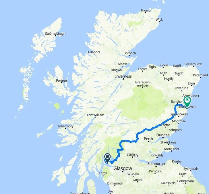
Click the map above to locate and download the gpx file from bikemap.net
The route starts at Helensburgh on the west coast, where the fault comes ashore on mainland Scotland. From there the route crosses the fault a number of times, following its path as close as possible as it traverses Scotland along to Stonehaven on east coast where the fault meets the North Sea. Along the way it takes in challenging climbs such as Dukes Pass & Cairn O' Mount (25km from the end) and riding through stunning places like Sma' Glen. 285 kilometers with 3,700m of climbing.

Cairn O’Mount, photo by Max East, published under creative commons
Challenge
With races and sportives and other road cycling events unlikely to have the go ahead in the near future, from 28th March until 25th October 2021 we are running a challenge for cyclists to set the fastest known time (FKT) on the proposed route. This will be in the “self supported” style with the clock starting when you pass the junction of West Clyde Street & James Street in Helensburgh and stopping when you reach the junction of Boatie Row & Braeside Crescent in Stonehaven. Intentional pacing from riders or vehicles will mean the ride is considered in the “supported” style.
If you want your time to be considered as the FKT then send an email to localclimbcc@gmail.com or reach out to me on Twitter, FB or Instagram.
We reached out to the people who maintain the FKT website in the hope of submitting the route we created but they are currently only selecting off road/gravel courses. They hope to add select road courses in future. So for now, FKT in various styles for the Highland Fault route will be posted on this page once verified.

Sma’ Glen (Glen Almond), photo by Spodzone published under creative commons